A question for Howard

Page may contain affiliate links. Please see terms for details.

Sp!ke

Administrator
Joined
Jun 2, 2002
Messages
11,968
Location
West London
Car
SL500 & The Fart Car
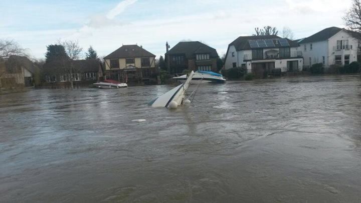
I just wondered how things were going at the lock with all this flooding going on.

I hear riverside drive was flooded so does that mean the lock is also breached?
 
No , the lock is fine. The headwater and tailwater are both very high but it's not out onto the lock side.

Riverside drive I suspect maybe groundwater flooding , rather than fluvial. That said , there is an awful lot of water coming down at the moment !

Currently 505 cubic metres of water a second , just over half a million litres a second , every second of every day !

Every gate on the weir is fully open and has been for weeks now !
 
Last edited:
Howard, Keep up the good work.
 
Yes keep up the good work Howard.:thumb:
 
I come over the Thames at Staines (on the train), and it looks decidedly soggy round there!
 
I normally commute through Datchet, Wraysbury and Staines.

Right now the whole area is underwater with many of the roads unpassable.
 
Is there any actual drop in height of the water above and below the lock?


I will have a look how the weirs on the Trent are doing, it would be a good time to try riding up them in a RIB.
 
Yes , we still have about 18 inches of fall at Tedders at the mo.

Although the tailwater is about 19' 3" ( normal is 10' 6" ) , the headwater is up by about 2' 6" , so there is still a small amount of fall.

Lots of bad things going on on the river at the moment .....

Here's one that happened near Wraysbury this morning :(

image_zps1be791a8.jpg
 
Last edited:
Sp!ke said:
I normally commute through Datchet, Wraysbury and Staines. Right now the whole area is underwater with many of the roads unpassable.

I came home tonight on the M2. Well I tried to

15ft-deep hole closes motorway
Last updated 3 hours ago


The Highways Agency said the hole measured 16ft (5m) by 6ft (2m) and was 15ft (4m) deep
A 10-mile (16km) section of motorway has been closed in both directions after a 15ft (4m) hole appeared in the central reservation.

Long tailbacks built up after the M2 in north Kent was shut between junction five, near Sittingbourne, and junction six, south of Faversham.

The Highways Agency said the hole measured 16ft (5m) by 6ft (2m).

A spokeswoman said the road would be reopened "when it is safe to do so".

'Inspect the hole'
She said: "The road has been closed while urgent safety checks are made following a large hole opening up in the central reservation.

"Agency staff and contractors are working hard to inspect the hole and make the necessary repairs and lanes will be reopened when it is safe to do so."

She added that there were delays both east and westbound in the area of the closure and urged drivers heading to and from the port of Dover to use the M20 instead.

The agency initially said the hole was 50ft deep. It is now investigating what caused it.

BBC © 2014

Sent from my iPhone using MBClub UK
 
Seems that it's mooring ropes were too tight , the rising waters pulled it gown and it sank at its mooring , then broke free.

Here's one of it going down ...
 
Last edited:
That is sad. I guess you get some shocked and upset owners. Is there a process to notify them? Or do they just show up.

Sent from my iPhone using MBClub UK
 
I suspect someone will have been in touch. In theory all thames boats are licenced , although sometimes the first we know of them are the bits floating downstream when they encounter a weir :(
 
I flew over the Thames from Hambledon to Caversham last week and Temple Island was only just visible, only because the building and the trees were above the water.
Henley looked dire, the Angel frontage had about 9 inches of clearance and the museum of the river was cut off by the water.
Below Shiplake lock the water was up by around 8 - feet and if I still had a boat at Tingdene marina at Caversham I would have been unable to access it due to all the approach roads being under water
Sonning bridge was clased to traffic and all of this was before the floods of this week.
It is only from the air that you can fully appreciate the extent of the floods.
When will it get back to normal.
 
According to the forecast tonight it looks like another two weeks before any sign of a 'dry' spell.
 

Users who are viewing this thread

Back
Top Bottom