Navigation
Install the app
How to install the app on iOS
Follow along with the video below to see how to install our site as a web app on your home screen.
Note: This feature may not be available in some browsers.
More options
You are using an out of date browser. It may not display this or other websites correctly.
You should upgrade or use an alternative browser.
You should upgrade or use an alternative browser.
Google Earth : Nurburgring now in higher resolution
- Thread starter scotth_uk
- Start date
Page may contain affiliate links. Please see terms for details.
GRAV888
MB Enthusiast
- Joined
- Mar 5, 2003
- Messages
- 6,324
- Location
- Rochester and Lancashire
- Car
- 2017 CLA 180 AMG in Black (mine) 2018 GLA 200 SE in Black (wifes)
So was Brands Hatch in Kent last time I looked.
Google earth is definitely getting better :bannana:
Google earth is definitely getting better
:bannana: glojo
Hardcore MB Enthusiast
Rather than start a new thread I thought I would use this one to mention how Google Earth is continually updating its database.
I am really impressed because six months ago Torquay was a green blob, then it had detail that was a few years old and now we are talking a few months. Who remembers my thread about how the paintwork of our Sprinter was terribly bleached?

In the bottom right corner of this picture you will see a 'pink' Sprinter stretched limo. Not bad when you consider it should be dark red
I am really impressed because six months ago Torquay was a green blob, then it had detail that was a few years old and now we are talking a few months. Who remembers my thread about how the paintwork of our Sprinter was terribly bleached?
In the bottom right corner of this picture you will see a 'pink' Sprinter stretched limo. Not bad when you consider it should be dark red
Who remembers my thread about how the paintwork of our Sprinter was terribly bleached?
Bleached? yeah right

Not so good for multi-storey car parks I guess ...
Sometimes but not always, a better image can be pulled up on FlashEarth, clicking on Microsoft VE box. Shots were taken at a different time period aswell.
http://www.flashearth.com/
http://www.flashearth.com/
glojo
Hardcore MB Enthusiast
When did you take that picture of our stretched limo?Bleached? yeah right
Does anyone know how Google Earth manages to get pictures with a cloudless sky?
Regards
John
glojo
Hardcore MB Enthusiast
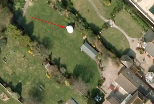
A loo with a viewNo guessing which garden is John's with his outdoor toilet

John
Does anyone know how Google Earth manages to get pictures with a cloudless sky?
Regards
John
They only do it in the Summertime (remember them? we used to get them once a year a long time ago) when your not likely to get many clouds...
My folks house is covered by cloud at the mo
- Joined
- Nov 6, 2007
- Messages
- 12,838
- Location
- North Oxfordshire
- Car
- His - Denim Blue A220 AMG Line Premium / Hers - Obsidian Black R172 SLK55
Yes, the camera that takes the shot is between the clouds and the ground. I'll explain...Does anyone know how Google Earth manages to get pictures with a cloudless sky?
The high-altitude shots are taken from satellite images. Satellites overfly the target areas pretty regularly, so it's not that difficult for them to get a shot they want without cloud. Now the clever bit that most people don't realise: as you zoom in for more detail the image switches to one taken from an aircraft which is flying below the cloudbase, hence no clouds in the shot.
Yeah ive noticed that, it tells you who owns the copyright at the bottom of the screen and it changed oftern depending on the height.
glojo
Hardcore MB Enthusiast
Thanks very much for the excellent and informative answer. The angles of some of the pictures have been bugging me and I have always suspected they might have been aerial pictures rather than taken from space.Yes, the camera that takes the shot is between the clouds and the ground. I'll explain...
The high-altitude shots are taken from satellite images. Satellites overfly the target areas pretty regularly, so it's not that difficult for them to get a shot they want without cloud. Now the clever bit that most people don't realise: as you zoom in for more detail the image switches to one taken from an aircraft which is flying below the cloudbase, hence no clouds in the shot.
Regards
John
- Joined
- Nov 6, 2007
- Messages
- 12,838
- Location
- North Oxfordshire
- Car
- His - Denim Blue A220 AMG Line Premium / Hers - Obsidian Black R172 SLK55
No worries. I'm a mine of useless information. Or so my friends tell me
This is not entirely correct. The only time an ariel photograph shot is displayed on Google Earth is when the latest version of satellite photo has not been made available, so their server shows the best available image. Aircraft do not, and could not cover the globe, beneath the cloudbase taking pictures.Yes, the camera that takes the shot is between the clouds and the ground. I'll explain...
The high-altitude shots are taken from satellite images. Satellites overfly the target areas pretty regularly, so it's not that difficult for them to get a shot they want without cloud. Now the clever bit that most people don't realise: as you zoom in for more detail the image switches to one taken from an aircraft which is flying below the cloudbase, hence no clouds in the shot.
All Satelitte imagery is supplied to Google Earth from Digital Globe, who operate the Worldview 1 and Quickbird satellites. The views are also taken from several angles from the satellite, hence the 3d digital effect.
chriswt
MB Enthusiast
- Joined
- Aug 12, 2005
- Messages
- 1,017
- Location
- Hertfordshire
- Car
- W203 C320cdi Sport, S-Max 2.0T Titanium Sport, 1974 Triumph Stag (needing restoration)
Rather than start a new thread I thought I would use this one to mention how Google Earth is continually updating its database.
I am really impressed because six months ago Torquay was a green blob, then it had detail that was a few years old and now we are talking a few months.
Thanks John, I've just checked out my house and I can see it at last!! :bannana:
- Joined
- Jul 18, 2007
- Messages
- 1,509
- Location
- church stretton/shropshire
- Car
- Mercedes ML 350 , E220 cabriolet Amg premium plus , Porsche 968 sports
lol ....were they on drugs when moding that van????????????Bleached? yeah right
glojo
Hardcore MB Enthusiast
That would also explain some of the angles, but some of the locations are definitely not satellite footage unless James Bond films are based on factThe views are also taken from several angles from the satellite, hence the 3d digital effect.
Regards
John
Silestanix
Active Member
I'll re-spray the top of your van for you John...for a fiver...
**Goes to B&Q for spray cans and laquer**
**Goes to B&Q for spray cans and laquer**
Users who are viewing this thread
Total: 2 (members: 0, guests: 2)
Similar threads
- Replies
- 0
- Views
- 401
Share: