Scotland route 500 sat nav advice

Page may contain affiliate links. Please see terms for details.

derektrotter

Active Member
Joined
Oct 12, 2013
Messages
214
Car
MB
Hi All

This sat we're planning a road trip to the highlands to do the first half of route 500 (Inverness to Bettyhill), I heard this part is the most scenic out of the whole route, hopefully thats correct?

Has anyone done this before who can advise a good way to stay on track on route500 using sat nav, e.g. are there any routes or apps I can download? I did a quick test on Google maps however it seemed like hard work to try and follow the route as it tries to cut thru a quicker route rather then follow route 500..

Advice appreciated :)
 
Last edited:
post 39 onwards. I used it to plan routes for NC500. There were limitations as it asked me to do a u turn at every point I had dragged the google route to suit my requirements. There was also a road across the mountain to Applecross not recognised by COMAND so car thought it was off-road.
Have used a later version of the software since to plan a grand tour of Italy and not found it as good.
 
Hi All

This sat we're planning a road trip to the highlands to do the first half of route 500 (Inverness to Bettyhill), I heard this part is the most scenic out of the whole route, hopefully thats correct?

Has anyone done this before who can advise a good way to stay on track on route500 using sat nav, e.g. are there any routes or apps I can download? I did a quick test on Google maps however it seemed like hard work to try and follow the route as it tries to cut thru a quicker route rather then follow route 500..

Advice appreciated :)
Most scenic is the bit from Durness to Ullapool. If you are going Inverness to Bettyhill up the East coast definitely not the best bit, I would recommend up the middle Bonar Bridge to Alt na Hara to Tongue at the top before going west to Durness.
 
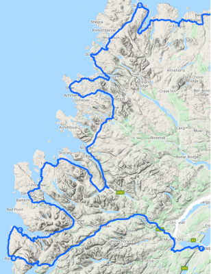
Thank you all, below is the route we're doing highlighted in blue, clockwise from inverness to bettyhill:
route500.png
 
Did it last week , used Google maps on the mobile phone and only suffered minimal signal loss mainly in the North West of the country.

We did it anti clockwise saving the best scenery for the last couple of days.

Inverness - Wick - Tongue - Ullapool - Applecross - Inverness.

The road from Unapool - Clachtoll -Inchnadamph is a bit tricky , more so than the (in)famous road from Applecross over the moor.

If you are only doing half of the route do the West coast as it is far more scenic than the rugged East coast.

Inverness -> Applecross -> Ullapool -> Bettyhill.

How are you planning on sleeping as most of the B+B`s / hotels are full , or they were last week ?

K
 
Thank you all, below is the route we're doing highlighted in blue, clockwise from inverness to bettyhill:

Here's the NC500 route in GPX format that I've converted for NTG4.5 if it works for you? It starts from Inverness Castle going clockwise so should be good for the part of route you're doing.
Have a good trip.
 

Attachments

  • NC500.zip
    90.6 KB · Views: 6
Thank you all, we have all hotels booked and also couple of tickets for the Jacobite steam train.

The car we're taking has no built in nav, I'll see if I can find a app which supports gpx import, thanks again for all the input so far :)
 
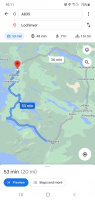
The best part of the NC500 isn't on the NC500, its the part between Ullapool and Lochinver.
If you're vehicle is less than 28ft I think you can do it, its not suitable for large motorhomes etc so its not on the route, if you're in a car or bike then do that bit.
 
The best part of the NC500 isn't on the NC500, its the part between Ullapool and Lochinver.
If you're vehicle is less than 28ft I think you can do it, its not suitable for large motorhomes etc so its not on the route, if you're in a car or bike then do that bit.
Ah, any chance you can put a screenshot of Google maps? We're going in a small car so should be fine to go to the bit your talking about :)
 
Any decent petrol station sells large scale AA maps for a few quid . How anyone can think of driving some of these remote areas without a map is beyond me . :eek:
 
We've got 2 phones with Google maps downloaded offline so not reliant on data and a backup map, we've just always use nav (maybe a age thing!) So wanted to stick with what we're comfortable with, worst case we have a map which we will use.
 
The grey bit is the NC500, the blue bit isn't.
Its worth the detour.
The way you're going the first road is a bit boring, but once you turn right its spectacular.
 
Thanks Cabriomat, to clarify are you saying skip the grey bit and detour via your blue bit or do both?

After zooming in your right theres hardly any roads so even following a map looks pretty straightforward :)
 

Users who are viewing this thread

Back
Top Bottom